 Pre-Colonial Togo Togo is believed to have human presence dating back 50.000 years (hunters and gatherers) and that agriculture in the area started about 5000 years ago in the forest zone surrounding the Togo Mountains and millet in the savanna to the north and south (source: www.anani.de/togo_history2.htm). Modern-day Togo contained several small chiefdoms, the most mentioned to be the Ewe (from Benin) in the South, the Gurma, Kabre, and the Guin and Mina (from Ghana). Just like the Fon and Aja people of modern-day Benin, the Ewe are part of the Gbe language groups. The Portuguese arrived in the late 15th century and traded at a small fort at Porto Seguro. Dutch, English, French and Danish people arrived in the 17th century. The Ewe people warred with the Dutch when they attempted to establish coastal forts in Ewe regions for its officials and merchants. Ewe people are notable for their fierce independence and have lacked group identity, and they have never supported a concentration of power within a village or through a large state. Village decisions have been made by a collection of elders, and they have refused to politically support strong kings, after their experience with the 17th century powerful despot named Agokoli of Notse. This has led to a lack of state, and their inability to respond to jihads and wars that followed in and after 18th century. The chiefdoms became victims to slave raids from their neighbouring major kingdoms of Dahomey, Asante in the South, and Mamprusi and Dagomba in the north (modern-day Ghana). Some reports also claim that the chiefdoms conducted slave raids themselves amongst each other and in Asante. Most of the slave traded happened through ports outside modern-day Togo, except for the port in Aneho. By the 18th century, the Danish dominated the trade along the Togolese cost. In 1802 they forbid slave trade and in 1850 they withdrew from the region. Instead, they sponsored missionaries to the area, most of them Germans. 10 years later, German merchants would arrive. Colonial Togo During the 1880, the French and British aggressively established colonies in the area and also made efforts to secure areas on the Togolese coast. The German merchants in Aneho were alarmed and appealed to the imperial government in Berlin to intervene. In 1884 the Germans forced a treaty from the chief of a small coastal village called Togo. The treaty granted Germany an exclusive protectorate over the entire coast of Togoland, which derived its name from this tiny chiefdom. The Germans quickly assumed control of the mostly Ewe region near the coast, but began their conquest of the interior (northwards) after 1893. They successfully subdued the north by 1897, although they confronted minor rebellions during the next few years. In 1897 they chose Lome, until then a small fishing village, as the colonial capital. The colony became a showcase for the Germans and was known to have an extensive infrastructure. The colonialists required 12 days of forced labour yearly from every able-bodied male in the colony to contribute to public projects. Alternatively the Togolese had to pay a cash penalty. The possibility of substituting a cash payment for forced labour encouraged many Togolese to cultivate cash crops or accept wage labour. This lead to a major cotton and cocoa industry in which Togolese often held ownership on plantations, and the Germans handled the trading. Togolese people were also recruited for positions in the local administration. The colony had little military personnel. The police force consisted of a small leadership team and less than 700 Togolese policemen in the country. When the First World War broke out, the Togoland governor suggested neutrality to the governor of Dahomey (French possession, modern-day Benin) and the governor of the Gold Coast (British possession, modern-day Ghana). The governor from the Gold Coast took it as a declaration of war and the governor of Dahomey refused the proposal. Both entered Togoland early in August 2014. Some – particularly the southern – areas were seized peacefully, whilst there have been battles in the north. Eventually, Togoland was completely taken over within a month. In December 1916 it was split into British and French occupation zones. If I understood this correctly, Togo was not formally a colony of either countries, but became a trustee under the rules of the League of Nations and later the United Nations. Video: A 4-minute must-watch about the battles in the north during the Togoland Campaign. This video also shows how badly the Germans treated locals in Togo Independence Beginning in 1947, the All-Ewe Conference, based in the Gold Coast, and the Comite de l'Unite Togolaise (CUT) argued before the UN Trusteeship Council for reunification of the French and British portions of Togoland, or alternatively for the unification of all Ewe territories, including those in the Gold Coast. The French viewed this Ewe unification movement with alarm because it played into the hands of Kwame Nkrumah's campaign to unify Togo with Ghana, which would eliminate French influence in the region. Meanwhile, in 1956 a plebiscite in British Togoland approved a merger with the Gold Coast, although a majority in the southern Ewe districts opposed the merger. British Togoland merged with the Gold Coast and in 1957 gained independence under Nkrumah as Ghana. The French held a referendum in 1956, approving the creation of an autonomous republic of French Togo, and Nicolas Grunitzky, a northerner, was appointed premier. Many Ewe people in the south opposed and boycotted elections due to heavy French involvement. After a protest by the mostly Ewe CUT to the United Nations, an election held in 1958 approved complete independence for Togo and replaced Grunitzky with a government led by CUT's Sylvanus Olympio. Togo proclaimed full independence on April 27, 1960 and a new constitution was installed in 1961. During the first term of Olympio’s precicendy, the country had four major parties – one of them the party of the president and one of them the party of Grunitzky. In 1962, the opposition parties were dissolved because of alleged plots against the majority party government (rivalries between the parties had begun in the 1940’s already). Many opposition members were jailed or fled the country. Olympio was assassinated by the military in 1963, apparently because officers were dissatisfied with conditions following their discharge from the French army. Grunitzky was reinstalled and soon elected as president. A new constitution was adopted alongside a multiparty government, trying to soften the tension between the north and the south. In in a coup d'état in 1967, Grunitzky was overthrown by Eyadéma Gnassingbé, a military man who already participated in the 1963 coup. He formed a new constitution and a new party, banning all others, until when in 1991 he allowed other political parties again. Yes, he still was in power in 1991 and remained in power until his death in 2005! His son, Faure Gnassingbé was instantly installed as his successor and remained in power ever since. The opposition claims elections in 2010 and 2015 to be fraudulent and do not represent the people's will. Recommended readings that are not cited in the text:
History of Togo: https://en.wikipedia.org/wiki/History_of_Togo Sources cited in the text: Gbe Languages: en.wikipedia.org/wiki/Gbe_languages Precolonial History of Togo: www.anani.de/togo_history2.htm Togoland: en.wikipedia.org/wiki/Togoland Ewe People: en.wikipedia.org/wiki/Ewe_people British Togoland: en.wikipedia.org/wiki/British_Togoland French Togoland: en.wikipedia.org/wiki/French_Togoland Togoland Campaign: en.wikipedia.org/wiki/Togoland_Campaign French Community: en.wikipedia.org/wiki/French_Community Sylvanus Olympio: en.wikipedia.org/wiki/Sylvanus_Olympio Eyadéma Gnassingbé: en.wikipedia.org/wiki/Gnassingb%C3%A9_Eyad%C3%A9ma Faure Gnassingbé: en.wikipedia.org/wiki/Faure_Gnassingbé
1 Comment
 The history of Benin is less complex but it's beautiful and it's beauty lasts until today. After reading about Nigeria last week and Benin this week, I'm also more and more amazed by the courage and power of women in African history that I have not found in any other history!! Let's just dig in. Throughout my research, I learned that historically there were about 3 different areas or cultures: Porto Novo, The Kingdom of Dahomey, and the northern part of the country that historically was more tribal. Some maps show that the Songhai Empire reached into some northeastern territories of present-day Benin, some don't. Aja and Fon People The Aja People are a group native to Tado in modern-day Togo and migrated to southern Benin in the 12th or 13th century. Around 1600, three brothers, Kokpon, Do-Aklin, and Te-Agdanlin, split the ruling of the region: Kokpon took the capital city of Great Ardra, reigning over the Allada kingdom; Do-Aklin founded Abomey, which would become capital of the Kingdom of Dahomey; and Te-Agdanlin founded Little Ardra, also known as Ajatche, later called Porto Novo (literally, "New Port") by Portuguese traders and the current capital city of Benin. The Aja People living in Abomey mingled with the local tribe, thus creating a new people known as the Fon, or "Dahomey" ethnic group. This group is now the largest in Benin. Another source claims the Aja were the rulers of Dahomey (Benin) until 1893/4, when the French conquered them. Today Tado is a centre of pilgrimage for Aja people from across the region, who visit the village each August to pray for their ancestral spirits. This is what I meant by writing that the beauty lasts until today. Fon and Aja people speak languages that are part of the Gbe language tree, which is also basis for languages in modern-day Ghana, Togo, and a small part of southwest Nigeria. Kingdom of Whydah The Kingdom of Whydah was an early kingdom in the south of present-day Benin, but I didn't figure out by who it was established. Between 1677 and 1681 it was conquered by a branch of the Akan People, a group migrating from the Sahara Desert and Sahel region of West Africa in the 11th century. Together with the other states in this area, this kingdom was a major slave trader. It was one of the areas that was then absorbed by the Kingdom of Dahomey in 1727 (see below). Kingdom of Dahomey Agaja, a King of Dahomey, reigning from 1708 to 1732, conquered most of the current area of southern Benin (except Porto-Novo), to establish direct contact with European traders. The expansion into that territory led to a feud between Dahomey and the Yoruba people of the kingdom of Oyo. Thus in 1738, the Alaafin, ruler of Oyo captured Abomey, capital of Dahomey, and he forced them to pay an annual tribute until 1823 when Dahomey ended its vassal status. During this time, the Fon of Dahomey conquered Yoruba cities, selling prisoners of war to the Portuguese. The Kingdom of Dahomey was an important regional power that had an organized domestic economy built on conquest and slave labor, significant international trade with European powers, a centralized administration, taxation systems, and an organized military. Notable in the kingdom were significant artwork, an all-female military unit known as the Dahomey Amazons. The Dahomey Amazons The Dahomean state became widely known for its corps of female soldiers "N'Nonmiton". They were organized around the year 1729 to fill out the army and make it look larger in battle, armed only with banners. The women reportedly behaved so courageously they became a permanent corps. In the beginning the soldiers were criminals pressed into service rather than being executed. Eventually, however, the corps became respected enough that King Ghezo (1818 - 1858) ordered every family to send him their daughters, with the most fit being chosen as soldiers. Many of the French soldiers fighting in Dahomey hesitated before shooting or bayoneting the N'Nonmiton. The resulting delay led to many of the French casualties. By the end of the Second Franco-Dahomean War, special units of the Amazons were being assigned specifically to target French officers. Colonial and Post-Colonial History The first Franco-Dahomean war (1890) occured as Dahomey's King at the time didn't want to recognize that the cities of Porto Novo and Contonou were part of a French protectorate when France (and Europe) was busy colonizing Africa. In the war, the French used their own forces, but mainly french-trained Senegalese and Gabonese tirailleurs. After suffering many losses in the fight for Contonou and not seizing Porto Novo, Dahomey's King recognized the two cities as part of the French protectorates but quickly re-armed itself wit modern weapons, purchased form German merchants. In 1982 the French Resident of Porto-Novo was attacked when investigating into a raid conducted by the Fon in the Ouémé Valley (see map below). When Dahomey's king rejected the complaints by the French, they declared war. Again making use of Senegalese tirailleurs, a series of battles followed for the next months, until in November 1983 the French seized the capital Abomey. The King fled north and was exiled to Martinique in 1984 when the French installed his brother as the next King. All of Dahomey was now a French protectorate and became a French colony in 1904: French Dahomey. The Kingdom of Dahomey was gone... :( 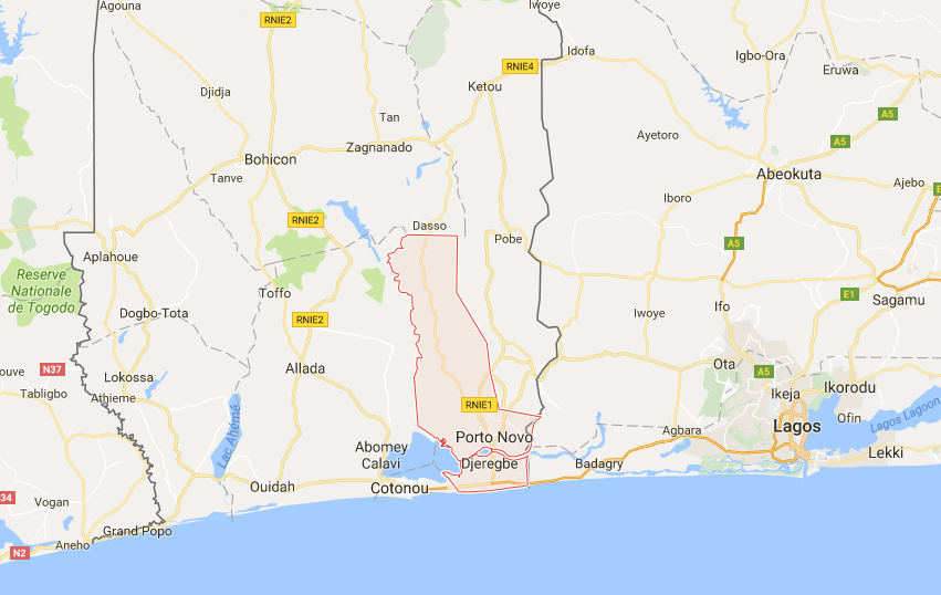 Map above: Ouémé Department in southeast Benin. You can now understand why the raid was in Ouémé Valley, Contonou and Porto Novo are just nearby. Also in this map: Lagos (Eko). In December 1958 French Dahomey became the self-governing colony called the Republic of Dahomey within the French Community (see my post about Mali) and gained full independence in 1960 with Hubert Maga as the president (Deputy of the French National Assembly since 1951). The problem was that now The Republic of Dahomey was not only made of people from the Kingdom of Dahomey, but also by the people of Porto Novo and the people in the northern territories. Also think that the north is more Muslim and the south more Christian. After several riots and military coups forced Maga to exile, he returned in 1970 to form a triumvirate Presidential Council, with the prime minister and president that were in power from 1964-1965 (between 1963 and 1970 the country was ruled by many different presidents and provisional governments, one of them only lasting as little as 2 days). These three represented each of the different areas and should have had a rotating presidency, however after Maga passed its initial power over to the second president, it was found that the two others undermined his position. A coup followed with the military taking over in 1972. In November 1975 the military leader established The People's Republic of Benin as a Marxist-Leninist state. The name apparently was given as the country lays at the Bight of Benin, which was itself named after the historic Nigerian Kingdom of Benin. In 1989, riots broke out after the regime did not have money to pay its army. The banking system collapsed. Marxism-Leninism was abolished, the country's name was officially changed to the Republic of Benin on 1 March 1990, after the newly formed government's constitution was complete. Elections were held in 1991, 1996, 2001, 2006, 2011, and 2016. The military leader ruling the Marxist state was eventually re-elected in 1996 and 2001, but because the constitution limits the presidency terms to two, power was finally passed on. The president elected in 2016 currently plans to limit the terms to a single one. Recommended readings that are not cited in the text:
Benin: https://en.wikipedia.org/wiki/Benin History of Benin: https://en.wikipedia.org/wiki/History_of_Benin Sources cited in the text: Aja People: https://en.wikipedia.org/wiki/Aja_people Agaja: en.wikipedia.org/wiki/Agaja Allada: https://en.wikipedia.org/wiki/Allada Akan People: en.wikipedia.org/wiki/Akan_people Dahmoey Amazons: en.wikipedia.org/wiki/Dahomey_Amazons Fon People: https://en.wikipedia.org/wiki/Fon_people King Ghezo: en.wikipedia.org/wiki/Ghezo Tado: https://en.wikipedia.org/wiki/Tadohttps://en.wikipedia.org/wiki/Tado Hubert Maga: https://en.wikipedia.org/wiki/Hubert_Maga Triumvirate Presidential Council: en.wikipedia.org/wiki/Presidential_Council_(Benin) Kingdom of Dahomey: https://en.wikipedia.org/wiki/Dahomey Kingdom of Whydrah: https://en.wikipedia.org/wiki/Kingdom_of_Whydah Akwamu: en.wikipedia.org/wiki/Akwamu Bonoman: en.wikipedia.org/wiki/Bonoman First Franco-Dahomean War: en.wikipedia.org/wiki/First_Franco-Dahomean_War Second Franco-Dahomean War: en.wikipedia.org/wiki/Second_Franco-Dahomean_War French Dahomey: en.wikipedia.org/wiki/French_Dahomey Republic of Dahomey: en.wikipedia.org/wiki/Republic_of_Dahomey People's Republic of Benin: en.wikipedia.org/wiki/People%27s_Republic_of_Benin 
From the glimpses I caught about Nigeria during the last weeks I already knew that I had to expect a huge amount of information. And so it was: This country, emerging from the Northern and Southern Nigerian protectorates, the Oil River protectorate, the Niger Coast Protectorate, and areas occupied by the Royal Niger Company, was and still is home to many more states, empires and kingdoms than any other so far. Some kingdoms were a thousand years old when the Europeans came in to rob Africa and destroyed their legacies. Because it would be way too much to write about, I will leave out the stories about the early Nok culture, the Kanem-Bornu Empire, and the Hausa States which later were conquered by the Fulani to become the Sokoto Caliphate. These stories were already covered in Niger last week, where they played a substantial role in the southern part of the country. In Nigeria they covered wide areas of the north, in what later became the Northern Protectorate, hence I will focus on Nigerian's south! Outside of African direct history I had to catch up a lot with European history too. I learned more about the Royal Niger Company and the 1884 Berlin Conference. In the late 19th century, Europe (predominantly Portugal, UK, France, Germany, and Spain) rushed to colonise the African continent for the exploitation of resources and precious metals. The conference was supposed to establish ground rules for a nation to claim a territory as its colony and determine some major borders. To gain public acceptance, one of the primary goals of the agreement was to stop slavery by African and Islamic powers. This reminds me of the time when the Bush administration sent military forces into Iraq to get control over the country, and to gain public acceptance they said it's for the destruction of weapons of mass destruction. Only that it was never proven that there were any. But let’s go back a few hundred years. Or thousands, because the oldest human skeletons found within today’s borders of Nigeria date back a 13.000 years. Kingdoms, Empires, States As mentioned earlier, the modern-day territory of Nigeria was filled with states, kingdoms and empires. Studying all of them would never be possible in a week’s time and so I focussed on a few only. I learned that some of them were heavily involved in slave raids and Sokoto is said to have had over 2 million of slaves. Also, especially around the Niger and the coast, the people were involved in trading goods and slaves with Europeans. The three largest ethnicities in Nigeria are said to be the Yoruba, Igbo, and the Hausa. Some of the biggest or most populous southern empires the country has seen in the past are Oyo (Yoruba), Borgu, Nupe, Nri and Benin. Instead of going through all of their histories individually, I created the chart below to show around what times these kingdoms existed and how they transformed. As mentioned earlier, when the Fulani people overtook the Hausa states, they became Sokoto (black arrow). The kingdom of Onithsa was founded by Igbo migrants from the Benin Empire (white arrow). The Kingdom of Warri was founded by a prince of Benin (red arrow). Eko, that the Portuguese later renamed to Lagos, was not actually part of Benin, but was a tributary to the empire. It was one of many major slave trade points and became a British colony in 1861 as the first one in the area of modern-day Nigeria. 
Chart above: Selection of some empires, states, and kingdoms with ethnicity and era. No guarantee that all data is correct, this is more to show the diversity and possible age of the states. Also shown: In what colonies they were integrated and Biafra. Not shown: Southern and Northern British Cameroon.
At this point it is also useful to show these two maps I have been referring to in almost every post so far. They are simply great. On first sight they seem confusing and full of too much data, but if you have been following my posts over the last 5 weeks, you realise how slowly you start seeing through the information, with every empire as a piece of the puzzle.


Maps above: Showing states, kingdoms, and empires in modern-day Nigerian territory. Very much recommended for future studies about Southern Nigeria: Benin, Borgu, Nupe, Oyo, Nri, Igboland
Slavery, Colonialism In mid-14th century the Portuguese started trading with the kingdoms close to the sea (e.g. Warri) and sent missionaries to spread Christianity over the areas. Some of these kingdoms conducted slave raids in the hinterlands and traded captured people with the Europeans. The Aro people from the coastal Kingdom of Arochukwu were heavily involved in this business. From 1901 to 1902 this very kingdom fought one of the biggest wars in resistance to British colonialism in the country’s history. In the first half of the 19th century the UK forbid any slavery amongst its territories. As the kingdoms on modern-day’s Nigerian coast were heavily involved in slave trading, Britain established Lagos as a colony in 1861 with the allegedly intention to prevent further human trafficking. After the Berlin Conference in the late 19th century Britain established the Oil Rivers Protectorate. Further north of the coastal empires, several trading companies did business with commodities and resources from Africa. In 1870 these companies were united into what later was named the Royal Niger Company, in order to rule out competition against each other and pushing other countries out of the trading areas. Even the African leaders that wanted to set up their own trading companies were forced into exile. The Royal Niger Company won more and more control and influence over the territories and signed treaties with local leaders. More and more other kingdoms suffered attacks from British colonial army’s that sometimes abused one African empire to overtake another one, before turning against it as well. In the 1900 the Oil River Protectorate, the Niger Coast Protectorate, Southern and Northern Nigeria were handed over to the Crown. 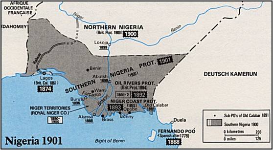
Map above: Showing the Nigerian Protectorates and the time they were established. Not shown: British Cameroon (which is within "Deutsch Kamerun" on this map). Source: DCStamps
Independence & Post-Colonial History In 1914 Southern and Northern Nigeria were merged into a single Colony (counting the Oil River and the Niger Coast Protectorates to Southern Nigeria). In 1929 there was the women's war, when about 10.000 women of different ethnic groups revolted against colonial powers and warrant chiefs. As a result, many chiefs had to resign and many native courts were destroyed. The new governor took some of the women's demands into account and from then on women also were able to become warrant chiefs and to serve on the native courts. Over the next decades there were other women's movements in the country. In 1960 Nigeria gained independence from the UK but had not yet the size of today’s nation. Nigerian’s neighbor Cameroon was first a colony of Germany. During the 1st World War however, a large part of Cameroon was taken over by the French and a rather small strip of the colony in the west – bordering Nigeria – was taken over by the UK and called British Cameroon. When Nigeria and (French) Cameroon gained independence in the 1960, this strip of British Cameroon was holding a vote in 1961 to join one of the two countries. At the time, British Cameroon was split into a northern (predominantly Muslim populated) and a southern protectorate. The Northern British Cameroon joined Nigeria whilst the south joined Cameroon. 
Map above: Showing Cameroon as a German Colony (orange), then taken over by France (blue) and the UK (red) in the late 1910's. British Cameroon is split into Northern and Southern Cameroon. Then independence as Cameroon (green) and finally Northern and Southern Cameroon joining Nigeria, respectively Cameroon. Also shown: Northern and Southern Nigeria merged into Nigeria (1914). Source: Wikipedia
In 1963 a constitution was in place. Because of cultural and political imbalances and corruption in elections, back-to-back military coups occurred in 1966. In 1967 the southeast of the country declared independence as a the Republic of Biafra but was reconquered in a 30 months war leaving 1 to 3 million people dead. Until 1979 the country was led by the military, but the following government was claimed to be incompetent, corrupt, and after a fraudulent re-election the military took over again in another coup mid-eighties. Another corrupt civilian regime was thrown over in a military coup just after its instalment in 1993. Yet only the death of the General in 1998 gave way for democracy, when his military successor adopted a new constitution and provided multiparty elections in 1999. Since then, presidential elections were held democratically and gradually gained the reputation to be free and fair. ---------------------------------------
Recommended readings that are not cited in the text:
History of Nigeria: https://en.wikipedia.org/wiki/History_of_Nigeria Early Histroy of Nigeria: https://en.wikipedia.org/wiki/Early_history_of_Nigeria Nigeria 1500-1800: en.wikipedia.org/wiki/History_of_Nigeria_(1500%E2%80%931800) Colonial Nigeria: https://en.wikipedia.org/wiki/Colonial_Nigeria First Nigerian Republic: https://en.wikipedia.org/wiki/First_Nigerian_Republic Second Nigerian Republic: https://en.wikipedia.org/wiki/Second_Nigerian_Republic Third Nigerian Republic: https://en.wikipedia.org/wiki/Third_Nigerian_Republic Fourth Nigerian Republic: https://en.wikipedia.org/wiki/Fourth_Nigerian_Republic Jukun People: https://en.wikipedia.org/wiki/Jukun_people_(West_Africa) Nupe People: https://en.wikipedia.org/wiki/Nupe_people Yorubaland: en.wikipedia.org/wiki/Yorubaland Igboland: en.wikipedia.org/wiki/Igboland Sources cited in the text: Women's War: en.wikipedia.org/wiki/Women%27s_War Nok Culture: https://en.wikipedia.org/wiki/Nok_culture The Kingdom of Warri: https://en.wikipedia.org/wiki/Kingdom_of_Warri Kingdom of Nri: https://en.wikipedia.org/wiki/Kingdom_of_Nri Aro People: https://en.wikipedia.org/wiki/Aro_people Anglo-Aro War: https://en.wikipedia.org/wiki/Anglo-Aro_War Nigeria 1901: http://www.dcstamps.com/?p=3809 Oyo Empire: https://en.wikipedia.org/wiki/Oyo_Empire Benin Empire: https://en.wikipedia.org/wiki/Benin_Empire Berlin Conference: https://en.wikipedia.org/wiki/Berlin_Conference British Cameroons: https://en.wikipedia.org/wiki/British_Cameroons British Cameroons Referendum: en.wikipedia.org/wiki/British_Cameroons_referendum,_1961 Nigerian Civil War: https://en.wikipedia.org/wiki/Nigerian_Civil_War Lagos Colony: https://en.wikipedia.org/wiki/Lagos_Colony Yoruba People: en.wikipedia.org/wiki/Yoruba_people Igbo People: en.wikipedia.org/wiki/Igbo_people Aro Confederacy: en.wikipedia.org/wiki/Aro_Confederacy 
Until about a week ago I didn’t know a thing about the diverse history of this country in the heart of West Africa, and I was pretty much surprised when I found out that from 7000BC to 3000BC the Sahara was green, full of rivers and home to gigantic lakes. Comment: Read my post about Burkina Faso from last week to better understand expressions marked with * and my post about Mali from two weeks ago to understand expressions marked with ** Please note I also updated Niger in my Timeline Chart (Click on "Chart" in the navigation bar). --------------------------------------- Today most of the Niger population lives in the south of the country, along the borders to Nigeria and Burkina Faso, or near Chad Lake, with the exception of Agadez and some other small cities and villages in the Sahara. However in prehistoric years this was different – the Sahara was home to several giant lakes, of which the Chad Lake was one, but it covered a much bigger area. The Sahara has been changing from desert to savanna and back for several times, remains found in the north of Niger date back 5000 years, 7000 years, and even 90.000 years, and belong to hunter-gatherers with a nomadic life-style. Around 3000 BC the Sahara was dry again, as we know the desert today. The Nok culture lived in the very south of the country (and most of Nigeria), from around 1000 BC and vanished around 300 AD. They were proficient in iron melting, which generally developed in sub-Saharan areas between 1500 and 1200 BC. The area of today’s Niger was at a major crossing point of trade routes and often visited by camel-riding Berber people. From the 3rd to 13th century the south-west of Niger and north-east of Burkina Faso were home to the Bura culture*. --------------------------------------- Over the centuries Niger was an area inhabited by several empires and cultures: The Kanem-Bornu Empire (South-East Niger) Around 700 AD the nomadic Kanembu people from Chad were forced southwest and settled down around the Lake Chad to build the Kanem Empire (north-west of Lake Chad). Some areas were taken over some areas from the Sao civilization that mainly lived south of the lake and wars between the two cultures continued until late in the 16th century. With the rule of the second dynasty from the late 11th century onwards the empire’s leadership was Islamic. In the 13th century this dynasty eventually declared jihad against surrounding tribes and expanded westward into modern-day Niger and Nigeria, as well as into Cameroon and Libya. After internal struggles the court abandoned the capital and moved to Bornu in 1380 (south-west of Lake Chad in modern-day Nigeria), living a more nomadic style again. By the late 16th century the king could reinforce control over Kanem and the two states merged into the Kanem-Bornu Empire. In the late 18th century the expansion of the Empire slowed down and Fulani people invaded the empire’s south-west during the Fulani War from 1804-1808, eventually establishing the Sokoto Caliphate in modern-day Nigeria and parts of south Niger. A declining Kanem-Bornu Empire was then conquered by a Sudanese warlord in 1893 who remained its lord until he was conquered by the French in 1900. 
Map above: The largest extent of the Kanem-Bornu Empire

Map above: Extent of the Sokoto Caliphate (earlier Hausa Kingdoms) next to Kanem-Bornu Empire
The Hausa-Kingdoms (South Niger) The Hausa Kingdoms were seven different states collaborating with each other and mainly occupying areas in Nigeria, but also south Niger. There are different theories about how they were founded, but most accounts claim that an Arab from Baghdad travelled westwards (at some point between 7th and 11th century) and married a local princess when arriving in the Kanem-Bornu Empire. After fleeing the empire he travelled further west and married again, having in total seven children with both wives, each of them would found one Kingdom. However, this also just might be a symbolic story about a naturally occurred migration into the area. The states however fell to the Fulani War, just like some areas of the Kanem-Bornu Empire. The Hausa Kingdoms were completely absorbed into the Sokoto Caliphate. Fulani War & Sokoto Caliphate (South Niger) The Fulani War broke out when an Islamic teacher was exiled from one of the Hausa states. At the time the government heavily taxed peasants and limited the influence of the Islamic power. After his followers were attacked by the king and publically exposed, the Islamic teacher lead his people into a holy war, conquering all Hausa states within a few years and expanding beyond in the years after. The entire area was now the Sokoto Caliphate that was conquered in 1903 by the British. Dendi Kingdom (South-East Niger) When the Songhai Empire broke apart** under the Moroccan invasion 1591, the leaders of its last dynasty fled from the capital Gao into their native Dendi region (south of Gao in Mali to Labbezanga). The Dendi Kingdom was established; however it often was under instable reigns, coups, and counter-coups. In 1901 it was conquered by French troops. Tuareg (Central Niger) Agadez was founded before the 14th century and became one of the most important Tuareg-Berber cities. Around 1500 it was conquered by the Songhai Empire, later the Ottoman Empire. Since 1900 it was ruled under the French, however until in the late 1910s a rebellion occurred, only in 1922 the desert Tuareg could be subdued fully into the Niger colony.
Map above: African Empires, showing Nok Culture, Hausa Kingdoms, and Kanem-Bornu Empire.
Sokoto is not shown
In 1958 Niger became an autonomous state within the French Community** and gained full independence 1960. The head of the counsel of Ministers during the two previous years became the country’s first president and he established a single-party state. He was overthrown by a coup d’état 1974 after a drought devastated the country and corruption in the government came to light.
The military stayed in power with two consecutive army leaders, while the second managed to implement a new constitution, still not allowing any other parties other than his own. Because of the demand of trade unions and student however, the president however changed this and after a transitional government was in place from 1991 to 1993, the first multi-party election could be hold under the third constitution. The elected government had a president and a prime minister, but as they were from different parties that over time got in conflict with each other, its stability trembled, what led to another coup d’état in 1996. The military leader organized and run elections later that year and participated as a contestant himself. However, he dissolved the electoral committee before voting had finished and appointed another, which subsequently announced him the winner. The questionable elected new president of Niger operated a regime with a high level of control, manipulation, and brutality. In 1999 he was assassinated by a military leader who in consequence established an international council to oversee the drafting of a new constitution. After elections the same year the council transitioned to civilian rule. The president arising from this election stayed in power for two terms until 2009. That year he was supposed to step down as the current constitution only allowed a presidency for two terms. But instead, he dissolved the court and changed the constitution under a boycott from the opposition, so he could stay president. These actions led to another coup d’état in 2010 and the president was put into prison. After a one-year transitional government and the implementation of the meanwhile seventh constitution, fair elections were held again in 2011. The next elections are due in 2016. Everything you have been reading in this post are things I didn't know until this very week. I understand there is so much more to learn about this country, but I need to move to the next one. I am very glad I have learned all this and if ever I come across a Nigerien, I am very proud to know some of her/his country's history. I have read and learned more than displayed here, but I summarized what interested me the most about the country's history. --------------------------------------- Recommended readings that are not cited in the text: Niger in General: https://en.wikipedia.org/wiki/Niger History of Niger: https://en.wikipedia.org/wiki/History_of_Niger Dendy People: https://en.wikipedia.org/wiki/Dendi_people Hausa People: https://en.wikipedia.org/wiki/Hausa_people Sources cited in the text: Agadez: https://en.wikipedia.org/wiki/Agadez Sahara Mega Lakes: http://www.kcl.ac.uk/sspp/departments/geography/people/academic/drake/Research/Research.aspx History of the Sahara: https://www.youtube.com/watch?v=1eUjXt49Qew Nok Culture: https://en.wikipedia.org/wiki/Nok_culture Metallurgy in Africa: https://en.wikipedia.org/wiki/Iron_metallurgy_in_Africa Berber People: https://en.wikipedia.org/wiki/Berbers 3rd-13th Century Bura Culture: https://en.wikipedia.org/wiki/Bura_culture Kanem Empire: https://en.wikipedia.org/wiki/Kanem-Bornu_Empire Sao Civilization: https://en.wikipedia.org/wiki/Sao_civilisation Second Kanem Dynasty: https://en.wikipedia.org/wiki/Sayfawa_dynasty Kanem-Bornu Empire: https://en.wikipedia.org/wiki/Bornu_Empire Fulani War: https://en.wikipedia.org/wiki/Fulani_War Sokoto Caliphate: https://en.wikipedia.org/wiki/Sokoto_Caliphate Sudanese Warlord Rabih Az-Zubayr: https://en.wikipedia.org/wiki/Rabih_az-Zubayr Hausa Kingdoms: https://en.wikipedia.org/wiki/Hausa_Kingdoms Bayajidda from Baghdad: https://en.wikipedia.org/wiki/Bayajidda_(mythology) Ottoman Empire: https://en.wikipedia.org/wiki/Ottoman_Empire Kaocen Revolt (Tuareg rebellion): https://en.wikipedia.org/wiki/Kaocen_Revolt French Community: https://en.wikipedia.org/wiki/French_Community 1974 Coup d’état: https://en.wikipedia.org/wiki/1974_Nigerien_coup_d%27%C3%A9tat 1996 Coup d’état: https://en.wikipedia.org/wiki/1996_Nigerien_coup_d%27%C3%A9tat 2009 Constitutional Crisis: https://en.wikipedia.org/wiki/2009-10_Nigerien_constitutional_crisis 2010 Coup d’état: https://en.wikipedia.org/wiki/2010_Nigerien_coup_d%27%C3%A9tat 
Burkina Faso took a lot of my time this week, but I really wanted to understand the very complex history of this country in detail. Until about a week ago I didn’t know what an exciting history Burkina Faso has, but very soon into my readings I came across the most interesting stories of a country with one of the most stable pasts and one of the most unstable presents.
Comment: Read my Post about Mali from last week to better understand expressions marked with a * Please note I also updated Burkina Faso in my Timeline Chart (Click on "Chart" in the nagivation bar) --------------------------------------- Its story begins with a population of hunter-gatherers that lived in the area between 14.000 and 5.000 BC. Agricultural settlements can be dated back to between 3600 and 2600 BC. The iron industry was developed by 1200 BC (in Sub-Saharan Africa, not just in Burkina Faso). By the 3rd century the Bura culture was established in parts of Niger and Burkina Faso and lasted until the 13th century. However as the sites were only discovered in 1975 there is not much known about these people yet. At some point between the 8th and 11th century however the Mossi people arrived. Still today descendants of this culture make up to 40% of Burkina Faso’s population. According to oral tradition the Mossi was a tribe resulting in the marriage of a Mandé* hunter and the Dagomba princess Yennenga. The Dagomba people lived in the northern part of today’s Ghana and still today most of their descendants still do. Apparently the princess got lost when she fled from her father who locked her up because she was such an important fighter (against Mandinka* people) and therefore he didn’t want her to get married. When she was found by the solitary elephant hunter after an exhausting escape, they felt in love and she gave birth to a boy called Ouedraogo. When this child grew older he visited the Dagomba king who gave him a small number of animals and horsemen. He used these to conquer surrounding tribes and formed the Mossi tribe when intermarrying between his own men and the conquered tribes. His grandson Oubri, who ruled around 1050 until 1090 ACE, is often considered founder of the Ouagadougou dynasty which ruled from the capital of Ouagadougou. 
Chart above: I created a diagram to show how the major Mossi Kingdoms were established. Click to enlarge.
Ouedraogo’s sons established other Kingdoms which were independent from each other. However around 1170 revolutions triggered the establishments of new Kingdoms, such as the Rizim Kingdom, and the Kingdom of Yatenga, that eventually took over Zondoma (see my chart above). At the time a system was introduced to administrate the kingdoms – The sons of kings were appointed as leaders of separate provinces with some autonomy but recognizing the sovereignty of the Ouagadougou dynasty. The leaders of all the separate states were called Naaba. 
Map above: If you've been reading my posts about Mali and Mauritania, this map should look familiar to you and you've seen the big area of the Mossi Kingdoms before, now you know what it's about.
The Mossi kingdoms became strong and at times attacked the Songhai Empire (mostly before the Mali Empire fell apart) and only Askia* the Great defeated by the end of the 16th century. However, when almost one hundred years later the Moroccan invasion* broke the Songhai Empire apart, the Mossi kingdoms re-established their independence. Until the late 19th century the kingdoms remained independent and performed very well in terms of economic and military power. Over the many centuries they never adopted Islam (with some exceptions), although the Songhai Emperor as well as nearby jihad states tried to spread the religion. One particular characteristic I was very impressed by the Mossi people is that they in the kingdoms they categorised the people into two classes: People with a lineage connection to the founders of the kingdoms were the political class and had the right to rule – the Naaba (state leader) for example came from this class. People living in the area before the Mossi arrived were the spiritual, they had no right to rule, however they were allowed to decide over issues related to land. People of the spiritual class came from different tribes (Dogon, Kurumba, Lela, Nuna, Sisala, Gurmantche, etc.) but around 1500 they all were united into the single ethnicity of Mossi. In 1896 France invaded the Mossi kingdoms, after already conquering all surrounding areas before, and collected them into the Upper Volta colony. The centralised administration system of having one primary leader in Ouagadougou and ministers governing different regions was kept. For some years however fights continued in the region and only in 1904 the French managed to integrate the areas into their already existing colony Upper Senegal and Niger. During World War I France recruited draftees from the territory to fight in Europe – the so-called Senegalese Tirailleurs. In 1915 and 1916 a coalition of people of different ethnicities fought against the French colonialists in the hope that they would be weakened because of the situation in Europe. They French army defeated them; however it was one of the most significant oppositions to colonial power anywhere in Africa, making history as the Volta-Bani War. In March 1919 France split the modern-day territory of Burkina Faso from the Upper Senegal and Niger colony in fears over other potential mobilisation of the locals. With the separation of the area they were able to reinforce administration, and named the new colony French Upper Volta. In September 1932 the colony was split up and its separate parts were integrated into the colonies of Ivory Coast, French Sudan (modern-day Mali), and Niger. The reason for the division being stagnating revenue of the colony, as plans to export cotton failed. In 1937 it was reconstituted as an administrative division called the Upper Coast. Following the end of World War II, the Mossi actively pressed France to reverse the decision from 1932 completely, and so it happened in 1947 that the colony of Upper Volta was revived with its previous borders. At this time being part of the French Union, Upper Volta selected to become a member of the French Community after the Loi-Cadre* was passed in France. This means from late 1958 on the State had its own internal independence but was still linked to France in military, currency, and external affairs. It was renamed into the Republic of Upper Volta and gained complete independence in 1960. The first government coming in place under independency banned all political parties other than its own, establishing a one-party state. It favoured French political and economic interests over the peasants or urban workers. In 1966 – after many protests and strikes – the military took over the nation’s leadership for the next four years. Until a new constitution was approved in 1977 the army’s Lieutenant however remained in power and in open elections in 1987 he was re-elected. The new government faced problems with the country’s powerful trade unions and in 1980 it was overthrown by a second Coup d’Etat. With yet another military government in place, the trade unions still resisted and in 1982 it was overthrown and replaced again, by the Council of Popular Salvation (CSP). Internal political struggles between the left and the right groups in this party arouse and when the leader of the left wing became prime minister in 1983 he was subsequently arrested. Efforts to free him resulted in a fourth Coup d’Etat, which successfully brought him back into power. He established the Committees for the Defence of the Revolution (CDR) to mobilize masses and implement the revolutionary programs. One of these measures was changing the name from Upper Volta to Burkina Faso, which means “the country of honorable people”. The regime was dominated by leftist military officers and had relations to the Soviet Union and Cuba in the time of the Cold War. However problems began to arrive with the implementation of the revolutionary measures and the CDR also clashed often with trade unions. In 1987 all leader was assassinated. His successor formed the Popular Front (FP) together with other founders of the CDR and rectified the previous leader’s deviations from the original goals of the revolution. In 1989 the FP started accepting other political parties. Surviving several plots and uprisings, the government lasted until October 2014 when opposition started another revolution. The President in charge since 1989 would no longer have been able to be re-elected in 2015 and his party tried to change this, so he could stay in power for further terms. The uprising of the opposition to this intention successfully overthrew the president and a new government was installed that survived another Coup d’Etat in September 2015. Everything you have been reading in this post are things I didn't know until this very week. I understand there is so much more to learn about this country, but I need to move to the next one. I am very glad I have learned all this and if ever I come across a Burkinabe, I am very proud to know some of her/his country's history. I have read and learned more than displayed here, but I summarised what interested me the most about the country's history. --------------------------------------- Recommended readings that are not cited in the text: Burkina Faso in General: https://en.wikipedia.org/wiki/Burkina_Faso History of Burkina Faso: https://en.wikipedia.org/wiki/History_of_Burkina_Faso Sources cited in the text: 3rd-13th Century Bura Culture: https://en.wikipedia.org/wiki/Bura_culture Since 8-11th Century Mossi People: https://en.wikipedia.org/wiki/Mossi_people Around 900-1000 Yennenga (Dagomba Princess): https://en.wikipedia.org/wiki/Yennenga Dagomba People: https://en.wikipedia.org/wiki/Dagomba_people Since around 1050-1090 Ouagadougou City: https://en.wikipedia.org/wiki/Ouagadougou Since around 900-1000 Mossi Kingdoms: https://en.wikipedia.org/wiki/Mossi_Kingdoms Dogon People: https://en.wikipedia.org/wiki/Dogon_people 1904 Upper Senegal and Niger (Colony): https://en.wikipedia.org/wiki/Upper_Senegal_and_Niger 1914-1017 Senegalese Tirailleurs: https://en.wikipedia.org/wiki/Senegalese_Tirailleurs 1915-16 Volta-Bani War : https://en.wikipedia.org/wiki/Volta-Bani_War 1919-1958 French Upper Volta (Colony): https://en.wikipedia.org/wiki/French_Upper_Volta 1958-1984 Republic of Upper Volta: https://en.wikipedia.org/wiki/Republic_of_Upper_Volta 1966 Upper Voltan coup d'état: https://en.wikipedia.org/wiki/1966_Upper_Voltan_coup_d'état 1980 Upper Voltan coup d'état: https://en.wikipedia.org/wiki/1980_Upper_Voltan_coup_d'état 2015 Burkinabé coup d'état : https://en.wikipedia.org/wiki/2015_Burkinabé_coup_d'état 
Wow, Mali! That was a lot of research, what a history!! I was reading through more than 30 different articles to understand every single bit, that no one ever taught us at school about. Well, it was worth the efforts, here the summary of my learnings this week, and its starts with the Mandinka people, who belong to the largest ethnolinguistic group of West Africa – the Mandé people.
--------------------------------------- The Mandé are descendants from ancient Central Saharan people and have several branches, of which one is the Mandinka, another one the Soninke. Between 2500 BC and 2000 BC the Soninke built stone settlement civilizations in the area of modern-day Mauritania, later they founded the Ghana Kingdom (Ghana stands for “warrior king”). When the Kingdom fell apart in around 1200, it left a number of successor states (see map below). 
Soumaoro Kanté, a 13th’century king of the successor state Sosso, seized the former Ghana capital and was conquering several neighboring states. This however came to an end when the Mandinka prince Sundiata Keita – who at the time lived in exile in Mema (another successor state of Ghana) – defeated him 1235 at the Battle of Kirina. Sundiata Keita then founded the Empire of Mali. In the East of the Ghana Empire the Songhai Kingdom existed, in an area where the Sorko, Gow, and Do people were the first settlers. Horse-riding Songhai speakers eventually subjugated them before the 10th century and first dynasties are recorded from the 11th century. Camel-riding Tuareg people and North-Africans traders joined the settlements near the Niger and the city of Gao became an important post as trading was flourishing due to the nearby Ghana Kingdom. The Songhai established Gao as a small Kingdom and became so successful, that it was conquered by the Mali Empire due to its attractiveness. In the 1430s Gao regained independence from a weakened Mali Empire that was in disputes over leadership succession. In the 1460s the Songhai ruler Sonni Sulayman Dama conquered the province west of Timbuktu, and his successor Sonni Ali conquered many of Songhai's neighboring states, including areas that fell off the Mali Empire. The Mali Empire itself continued co-exist alongside the Songhai Empire into the 16th century, but lost importance and strength. The Songhai Empire expanded and incorporated the remains of the Mali Empire. It saw its last great King in the late 15th/early 16th century - Askia the Great. As he grew old he was overthrown by his revolting sons, what resulted in a decline of the Empire. Finally, in 1591 the huge Empire fell at the Battle of Tondibi to the Moroccans, who at the time had firearms, invading the state to seize control and revive the trans-Saharan trade.
The maps above chronically show the extension of Mali Empire and Songhai Kingdom in 1350, the size of Songhai Empire (not the biggest extent of its history) and remains of Mali Empire around 1530, and the 1625 remains of the Empires and smaller successor kingdoms after the 1591 invasion of Morocco. However, the attempt of Morocco did not prove that successful. After the collapse of Songhai, no single state controlled the region, it was difficult for the Moroccans to keep the control, trade, and influence. Instead, a large number of small successor kingdoms arose. In 1880 France extended its colonial possessions in Senegal deeper into the continent of Africa - in what they called "Upper Senegal". According to my source the expansion was of a military rather than an economic or strategic reason, partly to seek promotional opportunities that the military personnel received, partly because of the fascination with the Mali and Songhai Empires. In 1890 the area was renamed into French Sudan, but underwent a number of territorial and name changes until 1920 when it became French Sudan again. Only in 1945 the country's borders were the ones that eventually will become the ones of Mali as we know them today. In 1956, under the pressure from independence movements in France's colonies, the French government passed the Loi-Cadre, a reform act that allowed African territories some independent powers and removed voting inequalities. French Sudan hold its first election in 1957 that was won by the African Democratic Rally (RDA). At the time, France was in its fourth republic and run into a crisis when French paramilitaries in Algeria threatened to take over Paris if not Charles de Gaulle (who retired from politics much earlier) was appointed president of France. Indeed they overtook Corsica in a bloodless coup and prepared to do the same with Paris. The reason for this revolt was that the French government did not support its troops in Algeria against the uprising Algerian War for independence. The military feared a similar scenario like the one in Indochina, where French colonialists were defeated by Asian troops, leaving many soldiers dead or capturing them in the years before. The French government finally agreed, appointed Charles to Gaulle as prime minister and created a new constitution which led France into its fifth republic. During the fourth republic, French colonies were part of the French Union. This was an expression to define that all colonies are part of France even when they don't border to France. The word colonies was not even used, it was all just one France. With the new constitution these colonies had the opportunity to remain French overseas territory, to become an overseas department (part of French Republic), or to become a state of the French Community. Most African continental states that were allowed to select one of these options (Algeria wasn't) chose to become part of the French Community. French Sudan was one of these countries and renamed itself to Sudanese Republic. The French Community gave the countries internal independence, while linking currency, foreign policy, and defense with France. In 1960 however, the Sudanese Republic and Senegal joined up for two months in what became the Mali Federation and successfully negotiated independence from France. When this was achieved, both countries of the federation mobilized their military forces, and Senegal withdrew from the partnership. The Sudanese Republic renamed itself as the Republic of Mali and its first president was the former premier of the Mali Federation. At first the country was a one-party state and opened up only very slowly during the eighties. In early nineties a student-led riot broke out and after four days of rioting the president was arrested by military officers. Within days they appointed a new civil government with a multi party democracy. In 2012 the National Movement for the Liberation of Azawad, a political and military organisation of Tuareg people, who originally come from the interior of the Sahara, tried to seize control over Azawad (big triangular north-east area of Mali). As the democratic elected president of Mali at the time did not handle this conflict well, military troops started a coup against the government. The Tuaregs were pushed out by their allies, of which some were Al Quaeda. The African Union and the French military finally were able to re-take the territory from the extreme Islamists. The Tuareg also fought against the Islamists, but battled the Malian military at the same time as well. In 2013 a peace deal between government and Tuareg people was achieved. Everything you have been reading in this post are things I didn't know until this very week. I understand there is so much more to learn about this country, but I need to move to the next one. I am very glad I have learned all this and if ever I come across a Malian, I am very proud to know some of her/his country's history. I have read and learned more than displayed here, but I summarised what interested me the most about the country's history. --------------------------------------- Recommended readings that are not cited in the text: Songhai People: https://en.wikipedia.org/wiki/Songhai_people Mali in General: https://en.wikipedia.org/wiki/Mali History of Mali: https://en.wikipedia.org/wiki/History_of_Mali Pre-Imperial Mali: https://en.wikipedia.org/wiki/Pre-Imperial_Mali Military History of the Mali Empire: https://en.wikipedia.org/wiki/Military_history_of_the_Mali_Empire African Empires (with map): https://en.wikipedia.org/wiki/African_empires May 1958 Crisis (Algeria): https://en.wikipedia.org/wiki/May_1958_crisis Sources cited in the text: Mandinka People: https://en.wikipedia.org/wiki/Mandinka_people Mandé People: https://en.wikipedia.org/wiki/Mandé_peoples Soninke People: https://en.wikipedia.org/wiki/Soninke_people Ghana Empire: https://en.wikipedia.org/wiki/Ghana_Empire Soumaoro Kanté: https://en.wikipedia.org/wiki/Soumaoro_Kanté Sundiata Keita: https://en.wikipedia.org/wiki/Sundiata_Keita Battle of Kirina: https://en.wikipedia.org/wiki/Battle_of_Kirina Mali Empire: https://en.wikipedia.org/wiki/Mali_Empire Tuareg People: https://en.wikipedia.org/wiki/Tuareg_people Sonni Ali: https://en.wikipedia.org/wiki/Sonni_Ali Songhai Empire: https://en.wikipedia.org/wiki/Songhai_Empire Askia the Great: https://en.wikipedia.org/wiki/Askia_Mohammad_I Battle of Tondibi: https://en.wikipedia.org/wiki/Battle_of_Tondibi French Sudan: https://en.wikipedia.org/wiki/French_Sudan African Democratic Rally: https://en.wikipedia.org/wiki/Rassemblement_Démocratique_Africain French Fourth Republic: https://en.wikipedia.org/wiki/French_Fourth_Republic Algerian War: https://en.wikipedia.org/wiki/Algerian_War Battle of Mang Yang Pass: https://en.wikipedia.org/wiki/Battle_of_Mang_Yang_Pass French Fifth Republic: https://en.wikipedia.org/wiki/French_Fifth_Republic French Community: https://en.wikipedia.org/wiki/French_Community Mali Federation: https://en.wikipedia.org/wiki/Mali_Federation National Movement for the Liberation of Azawad https://en.wikipedia.org/wiki/National_Movement_for_the_Liberation_of_Azawad Azawad: https://en.wikipedia.org/wiki/Azawad 
In the second week of my project I researched the history of Mauritania. Of course in a week's time there is not much to find out but I learned things I didn't know.
Mauritania derives its name from Mauretania that existed from 3rd century BC until 7th century AD in what today is Morocco (there is no overlap in the territories of present-day Mauritania and ancient Mauretania). Mauretania is itself an interesting part of history that was never covered in our lectures. I covered some of my findings about it below, however it makes more likely part of the history of Morocco which I will look into soon. --------------------------------------- According to my source it was an independent tribal Berber (an ethnic group of indigenous people of North Africa) Kingdom, however in the first century is became part of the Roman Empire. In the 430’s it fell to the Vandals, an East Germanic tribe occupying land in Poland, Spain, and North Africa. One hundred years later it became part of the Eastern Roman Empire (Byzantine) again until it felt to invading Arabs around 698. In 743 the Berbers finally reconquered the land and in 789 Morocco was build out of a unified Mauritania. I hope I understood this correctly, but from what I was reading, the Berbers who founded the Kingdom were called Mauri people, what leads to the Kingdom’s name. Berber languages are still spoken in Africa, mostly in Algeria, Mali, Lybia, Niger, Morocco, and some parts of Mauritania. In my time of exploring more about Mauretania and the Berbers I came across Kahina (or Dihyna), a queen, religious and military leader who led indigenous resistance to Arabic Islamic expansion in Northwest Africa. Sharing great interest in historical female leaders such as Bilkis (Queen of Sheba), I was very intrigued by her story and can recommend researching her. --------------------------------------- According to my source it is likely that since the Neolithic Era (10,200 BC – 4,500 or 2,000 BC) so-called Bafour people inhabited present-day Mauritania (as well as Senegal and Gambia). They often seem to be referred as pre-Berber people. When the camel was introduced as a means of transport in the western Sahara in the 3rd century, the Ghana Empire, that covered about half of the modern-day surfaces of Mauritania and Mali, grew strongly from trading. According to my source is must have existed from around 300 AD until 1200 AD, and when it fell apart it left a number of successor states behind. One of them was Songhay in the East and one was Mali in the South. Mali became so powerful that it extended into its own kingdom – the Mali Empire. Wide parts of the previous Ghana Empire were introduced into the Mali Empire that existed from around 1230 AD until 1600 AD. While the Ghana Empire was landlocked, the Mali Empire spread over Senegal and Gambia to the North Atlantic Ocean at its widest extends (around 1350). The Mali Empire now bordered Songhay in the East, which seems to me to have been existing between the area of Gao (in Mali) and Agadez (in Niger), overlapping with present-day Benin and Nigeria. When the Mali Empire started to fall apart, the Songhay Empire rose to an even bigger kingdom, covering surfaces of the previous Empire of Mali and previous Empire of Ghana. In the West the Mali Empire became the Wolof Empire - present-day Senegal. This map gives a great idea (source from https://en.wikipedia.org/wiki/African_empires):
The Songhay Empire existed from the 15th to the 16th century and after its collapse it founded the Dendi Kingdom, a state in present-day Niger, lasting for over 300 years until 1901. When the Gold Coast became independent from Colonialism in 1957, it was named Ghana in honor of the ancient kingdom (although the surface of Ghana never was part of the Ghana Empire). Also in 1901 France started to conquer Mauritanian emirates, that were now completely Muslim through the introduction of Islam through Arabs conquering North Africa. Mauritania was not primarily affected by the 3 expansions of Islam into North Africa before 1000 AD, however the religion was introduced gradually through trading with the Arabs in the North as well as Arab Slavery. Having the country’s outlines drawn up and planned in 1904, France absorbed the territories from the Senegal River upwards. Apparently Mauritania was interesting for the French in order to connect their Northern and Western colonial territories (e.g. Algeria invaded since 1830 and Senegal since 1659). In 1960 Mauritania became independent, after its level of political and economic development was in an embryonic stage. The country was colonized for “only” 40 years, 90% of the population was still nomadic, and the capital was founded at the site of a small colonial village. First being a one-party state, guided by a president originally installed by the French, the country was brought to a near-collapse in a war to annex parts of Western Sahara (that was a former Spanish colonial territory) in order to create a Greater Mauritania. What followed was a military government aimed for national recovery (1978 onwards), that withdrew from the annexation of Western Sahara. In 1991 political parties were legalized again; however the Colonel from the military government won all elections until a military coup against him in the year 2005. In 2007 the first post-military state rules multi-candidate elections were held. In 2008 there was a military coup against the president elected in this vote, who was accused of having created an authoritarian regime. The president resigned under protest, however this allowed the leader of the military coup to hold new civilian elections which he won and still is in power today. I had to search a bit wider until I understood why Mauritania is almost exclusively Muslim. In my readings I came across the Spread of Islam which is possibly one of the most interesting lectures I ever found and no one at school taught us about. Of course we learned everything about the Spread of Christianity but nothing about Islam. So I was glad to start digging into this topic and reading about the three major steps of this development. I will not go too far into it now because I’m sure I will read more about it soon. What I did notice is that throughout all the three major spreads Mauritania was never actually (or only partially) affected. According to another source the Islamization of Mauritania was a gradual process over many hundred years, mainly happening through contacts between Berbers and Arab merchants, who came from North African territories conquered during the Muslim conquest of the Maghreb (Libya, Tunisia, Algeria, Morocco, Western Sahara, Mauritania). Another source mentions that slowly the Arab presence was growing, forcing the Berbers to move further south (they didn’t want to mix with other groups) and by the 16th century most of them were pushed to the Senegal River. Those remaining in the north became slaves. Everything you have been reading in this post are things I didn't know until this very week. I understand there is so much more to learn about this country, but I need to move to the next one. I am very glad I have learned all this and if ever I come across a Mauritanian, I am very proud to know some of her/his country. I have read and learned more than displayed here, but I summarised what interested me the most about the country's history. Recommended readings used for sources: Mauritania in General: https://en.wikipedia.org/wiki/Mauritania Berber Kingdom of Mauretania: https://en.wikipedia.org/wiki/Mauretania Berbers: https://en.wikipedia.org/wiki/Berbers Mauri People: https://en.wikipedia.org/wiki/Mauri_people Kahina: https://en.wikipedia.org/wiki/Kahina Bafour: https://en.wikipedia.org/wiki/Bafour Precolonial Mauritania: https://en.wikipedia.org/wiki/Precolonial_Mauritania Ghana Empire: https://en.wikipedia.org/wiki/Ghana_Empire Mali Empire: https://en.wikipedia.org/wiki/Mali_Empire Songhai Empire: https://en.wikipedia.org/wiki/Songhai_Empire African Empires (with map): https://en.wikipedia.org/wiki/African_empires History of Mauritania: https://en.wikipedia.org/wiki/History_of_Mauritania French conquest of Algeria: https://en.wikipedia.org/wiki/French_Algeria French conquest of Senegal: https://en.wikipedia.org/wiki/French_conquest_of_Senegal More about Mauritania History: http://countrystudies.us/mauritania/ --------------------------------------- Muslim conquest of the Maghreb: https://en.wikipedia.org/wiki/Muslim_conquest_of_the_Maghreb Spread of Islam: https://en.wikipedia.org/wiki/Spread_of_Islam Islamization of the Sudan Region: https://en.wikipedia.org/wiki/Islamization_of_the_Sudan_region Arab Slave Trade: https://en.wikipedia.org/wiki/Arab_slave_trade  In the first week of my project I researched the history of Cape Verde. Of course in a weeks time there is not much to find out but I learned things I didn't know. Like that the basic structures of the islands date back to 150 million years ago, but that they were not populated by humans until the 15th century when Portuguese navigators discovered them. However it is possible that Arabs visited the islands earlier already, and maybe even by Moors (Muslim inhabitants of the Maghreb), Wolof People (ethnic group in Senegal, Gambia, and Mauritania), Serer (a West African ethnoreligious group), and Lebou fishermen from the Guinea (region) coast.
According to my source the country's economy was heavily based on slave trade and when that horrible chapter came to an end there was an economic crisis. Apparently today the country is making business through services and foreign investments, especially on the African continent. I also learned that the islands were attacked regularly by pirates. In the 1950ies Cape Verde and Guinea-Bissau formed the "African Party for the Independence of Guinea and Cape Verde" (PAIGC) in order to become independent from Portugal. According to my source this group started a rebellion against Portugal in the sixties, which led to a war in Guinea-Bissau. The party then controlled a majority of Guinea-Bissau, but not of Cape Verde. At the time a right-wing regime ruled in Portugal (Estado Novo, or Second Republic) which saw itself as a pluricontinental state, maintaining territories in Africa such a Cape Verde (and Guinea-Bissau, Angola, Mozambique, and others) and Asia. On the 25th April 1974 the Carnation Revolution happened, where a left-wing military coup successfully overthrew the regime, which resulted in a decolonisation - Guinea-Bissau and Cape Verde became independent (among others). After this, Cape Verde became a single-party state until September 1990 and held first elections with multiple parties in 1991. Since 2013 the country is supposed to be called "Cabo Verde", even in English context. Everything you have been reading in this post are things I didn't know until this very week. I understand there is so much more to learn about this country, but I need to move to the next one. I am very glad I have learned all this and if ever I come across a Cabo Verdian, I am very proud to know some of her/his country. I have read and learned more than displayed here, but I summarised what interested me the most about the country's history. Recommended readings used for sources: Cape Verde in General: https://en.wikipedia.org/wiki/Cape_Verde History of Cape Verde: https://en.wikipedia.org/wiki/History_of_Cape_Verde Second Republic of Portugal: https://en.wikipedia.org/wiki/Estado_Novo_(Portugal) Carnation Revolution (end of regime): https://en.wikipedia.org/wiki/Carnation_Revolution |
AuthorTanja Gut Archives
November 2016
Categories |

 RSS Feed
